Wiki-Solar mapping
See utility-scale solar projects shown by placemarkers on a map or by a site footprint

What's on the maps?
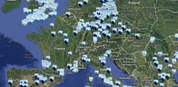
We show the location of the projects from our extensive database in the form of place markers on a world map. We used the resources of Google Maps to give access to user-friendly facilities for navigating, zooming in and out, and switching between satellite, map and hybrid views. Because of file size limitations, maps for densely covered regions may be broken down into sub-regions, or partial maps may be displayed.
For more on the criteria for selecting the projects to display on the maps, see here.
Our maps
... are available in two formats:
Project locations
Select a country or region from the pull-down menus above. See China, for example, by pressing this large button >
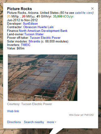
Click on any place-marker and it will display the name and what details of the project are held on the Wiki-Solar Database as described on the right. There will also be a hyperlink to the site plan (if available) as below:
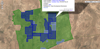
Plant site plans
Additionally, for all projects for which we have a site plan, these can be shown on an alternative view, which displays the outline of the site.
You can pan and zoom in and out on this map to see other nearby projects. You can also see the footprints of selects solar parks and regions using the 'Solar Parks' and 'Clusters & Sites' menus above.
Press this button > to see Charanka Solar Park, for example.
Regional maps
Specific maps for individual countries, continents and regions are available from here.
Company maps
Similarly maps showing all the projects for major participants in the sector are available from here.
What's on the placemarkers?
When you click on a placemarker (or site footprint) it opens up to show the name of the plant, and lists other details available on the Wiki-Solar Database. There will also be a hyperlink to the site footprint (if available).
An additional service available to customers who order project lists, provides a time-limited voucher to access detailed versions of the maps, where the placemarkers show fuller details of the project participants and technology used, as illustrated below.
@WikiSolar | Standard | Copyright © WolfeWare Ltd |